Most capital cities have a geographical origin of coordinates, which is used when making maps for the country. All cities also have a zero point for road distances from the city center to other points. Why do capital cities need an origin of coordinates? In the past, finding coordinates, especially the longitude, was so hard that the best way was to pick a local origin, do astronomical observations at that point, and then do triangulation for the rest of the country. That's why the origin of coordinates is often at observatories.
In London the origin of coordinates is at Greenwich, while the zero point for road distances is at Trafalgar Square. In Oslo the origin of coordinates is at the Observatory, while the zero point for road distances is at Stortorvet. But what about Singapore? After a bit of detective work, and a lot of help from various people, I found that the origin of coordinates is at Empress Place and the zero point for road distances is at the old General Post Office, now the Fullerton Hotel.
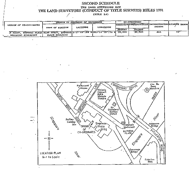
I started out by asking a lot of people and organizations, but the first useful lead came from the Meteorological Services. They pointed me to the The Land Surveyors Board at the Ministry of Law, who kindly informed me that “The Origin of Co-ordinates is the Flagstaff at Empress Place Building in which the Origin of Meridian of Reference is 1°17'15.528"N and 103°51'10.808"E.”. They also sent me the map below.

I rushed down to Empress Place to look for the flag pole. I found two statues of Sir Stamford Raffles and a statue of a Thai elephant, but no flag pole. I e-mailed back to the Land Surveyors Board, who again helped me out. They informed me that “I understand that the flag staff has since been physically removed as the said building is currently under refurbishment to contain the 2nd wing of the Asian Civilisation Museum.” I then e-mailed a friend at the Asian Civilisation Museum and wondered if they were aware of this “cultural vandalism”. They told me that it wasn't they who had torn down the flag pole. They claimed it had been torn down during the renovation of the old Empress Place Museum.
For a long time, that was all I knew, but after a lecture on the Chinese calendar at the Department of History at the National University of Singapore I got in touch with Mok Ly Yng (who also helped me with the page Why is Singapore in the “Wrong” Time Zone?), and all my questions were resolved!
Mok Ly Yng had this to say about the flag pole. “I used to work in the National Mapping Agency of Singapore - Mapping Unit of the Ministry of Defence and did some research on this. From about 1870 to 1920, there was no separate Survey Department in the Straits Settlement. It was part of the Public Works Department (PWD) and served as the PWD's Survey Branch. The head of the PWD was the Colonial Engineer. His full title from c.1870 to 1920 was 'Colonial Engineer and Surveyor General'.”
“The use of Cartesian co-ordinates for surveys in Singapore probably started in or after 1875. The Flagstaff was chosen as the Origin in 1890 when the first ever 'proper' Triangulation of Singapore was conducted by the Survey Department. The PWD with many other colonial offices were located in the building now called Empress Place Building (named in 1907 I think). At that time, the building was simply known as the 'Government Offices'. So, I suppose it was out of convenience that when the first Triangulation of Singapore Island was started in 1890, the starting point or Origin was right on top of the Survey Office's own roof-top where the flagstaff stood.”
“Before 1890, the Origin of co-ordinates was not at the Government Office. It was somewhere at Bukit Mandai, rather north part of the island. Why there? I am still digging.”
“And, there have been at least three different sets of Lat/Long values for that exact same spot as portrayed in the empress.GIF file. One set is used by the Survey Department of Singapore, which is the one printed in the gif file. The other set is used by Mapping Unit for topographical mapping use. The third set of value was adopted by the British Admiralty for Hydrographic charting purposes. So, it is not a unique pair of value. The d(Long) between 1st and 2nd set is about 13 metres to the east. d(Lat) is rather small, can't recall the magnitude nor direction off-hand. Not surprising that the greater component of error is in the Longitude.”
“The Flagstaff was already gone in the 1930's but the hole in the roof was still present until at least the 1980's. My ex-colleagues went back just a few months ago to inspect the spot but found that not even the remnants of the base of the flagstaff has survived. Sadly, the part of the roof where the original flagstaff used to stand was removed entirely and refitted with a glass one to serve as a skylight for the new ACM.”
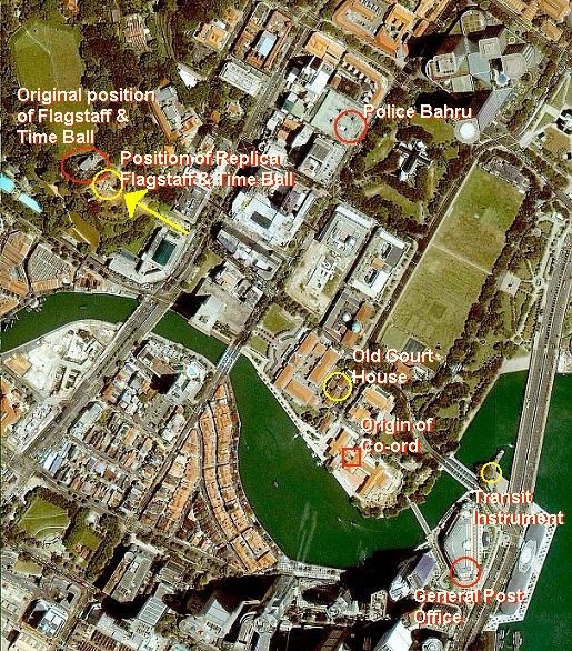
I think it is a shame that there is no indication of this spot, but thanks to the map you can still get an idea where it was.

|
| Space Imaging's IKONOS satellite |
However, the origin of co-ordinates is currently scheduled to be moved in 2005 to a point with coordinates 103° 50' 00" E and 1° 22' 00 N. This point is in Peirce Reservoir and has been chosen to simplify computations.
But what about the the zero point for road distances? Mok Ly Yng informed me that it is at The Fullerton Hotel. It used to be called the Fullerton Building and housed the General Post Office.
Regarding the earlier history, had this to say. “From around 1870s/1880s, the zero-mile point was at the 'centre gate of Police Bahru'. 'Police Bahru' was at the site of today's Capitol Centre, located along North Bridge Road directly facing St. Andrew's Cathedral. 'Bahru' means 'New' in Malay. Police Lama (lama means 'old') referred to the Central Police Station along South Bridge Road, on the other side of the Singapore River. From my observation and guesswork, it should be near the lamp post closest to the taxi-stand at Capitol Centre. Earlier than 1870s/1880s, my speculation is the 'Old Court House' (now Old Parliament House). This was built in 1827 and housed many of the government offices. It was not until Empress Place Building was completed in 1867 that the government offices moved into the new building. The Survey Department (still part of the PWD) remeasured the mile stones from the General Post Office from 1909 to 1910. Before Fullerton Building was built, the General Post Office was already at the same site, but in a different and smaller building. This original building was torn down to construct Fullerton Building. One of the reasons for the change was that the Police force had moved out of Police Bahru along North Bridge Road to their new barracks on Pearl's Hill. So, the mile stones as measured from Police Bahru would have no practical use any longer. In 1928, after Fullerton Building was completed, not only was the General Post Office set up in there, the Survey Department moved into its 5th floor. The PWD continued to be housed in the Government Offices (i.e. Empress Place Building). The building is now the Fullerton Hotel.”
There used to be a time ball in Fort Canning Park. Mok Ly Yng informed me that “The National Parks have replicated the Flagstaff, the Light House and the Time Ball in the park, facing the sea, along Hill Street. The original position for these objects has been occupied by the telecommunications tower and SingTel building . It has been fenced up and made inaccessible. Therefore, the replicas are now placed slightly lower, on a terrace known as Raffles Terrace.”
“Incidentally, the Observatory for Time Ball was not on Fort Canning, but on Mount Faber, where there were another Time Ball and Flagstaff. Observations were made at Mount Faber and the time signal transmitted by telegraphic means to Fort Canning for the raising and dropping of the Time Balls. Hence the Fort Canning Time Ball served only as a signal repeater of sorts. The Mount Faber site is also now occupied by other wireless tower and SingTel building.”
By the way, do you wonder why there are two statues of Raffles? The bronze sculpture was originally unveiled on the Padang in 1887, but moved to its present location outside Victoria Theatre in 1919. It was placed in the National Museum (then called the Raffles Museum) by the Japanese during the war, but returned in 1946. In 1972 the white copy was put up at the Landing Site opposite Boat Quay.
Back to the page for my course Heavenly Mathematics & Cultural Astronomy.
Web Server Statistics for Helmer Aslaksen, produced by Analog.
I use the W3C MarkUp Validation Service and the W3C Link Checker.