
Portal:World
The World Portal


The world is the totality of entities, the whole of reality, or everything that exists. The nature of the world has been conceptualized differently in different fields. Some conceptions see the world as unique while others talk of a "plurality of worlds". Some treat the world as one simple object while others analyze the world as a complex made up of parts.
In scientific cosmology, the world or universe is commonly defined as "[t]he totality of all space and time; all that is, has been, and will be". Theories of modality talk of possible worlds as complete and consistent ways how things could have been. Phenomenology, starting from the horizon of co-given objects present in the periphery of every experience, defines the world as the biggest horizon or the "horizon of all horizons". In philosophy of mind, the world is contrasted with the mind as that which is represented by the mind. Theology conceptualizes the world in relation to God, for example, as God's creation, as identical to God or as the two being interdependent. In religions, there is a tendency to downgrade the material or sensory world in favor of a spiritual world to be sought through religious practice. A comprehensive representation of the world and our place in it, as is found in religions, is known as a worldview. Cosmogony is the field that studies the origin or creation of the world while eschatology refers to the science or doctrine of the last things or of the end of the world.
In various contexts, the term "world" takes a more restricted meaning associated, for example, with the Earth and all life on it, with humanity as a whole or with an international or intercontinental scope. In this sense, world history refers to the history of humanity as a whole and world politics is the discipline of political science studying issues that transcend nations and continents. Other examples include terms such as "world religion", "world language", "world government", "world war", "world population", "world economy", or "world championship". (Full article...)
Selected articles -
-
![Image 1 Protestors clash with Hong Kong police in the Wan Chai waterfront area during the WTO Ministerial Conference of 2005. Since its creation in 1995, the World Trade Organization (WTO) has worked to maintain and develop international trade. As one of the largest international economic organizations (alongside the International Monetary Fund (IMF) and the World Bank), it has strong influence and control over trading rules and agreements, and thus has the ability to affect a country's economy immensely. The WTO policies aim to balance tariffs and other forms of economic protection with a trade liberalization policy, and to "ensure that trade flows as smoothly, predictably and freely as possible". Indeed, the WTO claims that its actions "cut living costs and raise standards, stimulate economic growth and development, help countries develop, [and] give the weak a stronger voice." Statistically speaking, global trade has consistently grown between one and six percent per annum over the past decade, and US$38.8 billion were allocated to Aid for Trade in 2016. Yet several criticisms of the WTO have arisen over time from a range of fields, including economists such as Dani Rodrik and Ha Joon Chang, and anthropologists such as Marc Edelman, who have argued that the institution "only serves the interests of multinational corporations, undermines local development, penalizes poor countries, [and] is increasing inequality", and have argued that some agreements about agriculture and pharmaceutical goods have led to restricted access to food and healthcare, thus causing large numbers of deaths. Several factors are alleged to contribute to these conditions, including but not limited to: the most favoured nation rule (MFN), national treatment policies, and failure to regard the infant industry argument. Critics argue that the policies that support these principles fail to protect developing nations, and in some cases take advantage of them. For example, UNCTAD estimates that market distortions cost developing countries $700 billion annually in lost export revenue. (Full article...)](https://cdn.sessionspy.com:443/index.php?//upload.wikimedia.org/wikipedia/en/d/d2/Blank.png)

Protestors clash with Hong Kong police in the Wan Chai waterfront area during the WTO Ministerial Conference of 2005.
Since its creation in 1995, the World Trade Organization (WTO) has worked to maintain and develop international trade. As one of the largest international economic organizations (alongside the International Monetary Fund (IMF) and the World Bank), it has strong influence and control over trading rules and agreements, and thus has the ability to affect a country's economy immensely. The WTO policies aim to balance tariffs and other forms of economic protection with a trade liberalization policy, and to "ensure that trade flows as smoothly, predictably and freely as possible".
Indeed, the WTO claims that its actions "cut living costs and raise standards, stimulate economic growth and development, help countries develop, [and] give the weak a stronger voice." Statistically speaking, global trade has consistently grown between one and six percent per annum over the past decade, and US$38.8 billion were allocated to Aid for Trade in 2016.
Yet several criticisms of the WTO have arisen over time from a range of fields, including economists such as Dani Rodrik and Ha Joon Chang, and anthropologists such as Marc Edelman, who have argued that the institution "only serves the interests of multinational corporations, undermines local development, penalizes poor countries, [and] is increasing inequality", and have argued that some agreements about agriculture and pharmaceutical goods have led to restricted access to food and healthcare, thus causing large numbers of deaths. Several factors are alleged to contribute to these conditions, including but not limited to: the most favoured nation rule (MFN), national treatment policies, and failure to regard the infant industry argument. Critics argue that the policies that support these principles fail to protect developing nations, and in some cases take advantage of them. For example, UNCTAD estimates that market distortions cost developing countries $700 billion annually in lost export revenue. (Full article...) -

Miss Universe is an annual international major beauty pageant that is run by a United States and Thailand-based Miss Universe Organization. Along with Miss World, Miss International, and Miss Earth, it is one of the Big Four beauty pageants.
The Miss Universe Organization and its brand, along with its sister pageants, Miss USA and Miss Teen USA, is currently owned by JKN Global Group and Legacy Holding Group USA Inc., an American division of Mexican company Legacy Holding through the joint venture company JKN Legacy Inc. Telemundo has the licensing rights to air the pageant through 2023. The pageant's advocacy is "humanitarian issues and is a voice to affect positive change in the world." (Full article...) -

King Sargon II of the Neo-Assyrian Empire (right) had the full titulature of Great King, Mighty King, King of the Universe, King of Assyria, King of Babylon, King of Sumer and Akkad. Stele housed at the British Museum, London.
King of the Universe (Sumerian: lugal ki-sár-ra or lugal kiš-ki, Akkadian: šarru kiššat māti, šar-kiššati or šar kiššatim), also interpreted as King of Everything, King of the Totality, King of All or King of the World, was a title of great prestige claiming world domination used by powerful monarchs in ancient Mesopotamia. The title is sometimes applied to God in the Abrahamic tradition.
The etymology of the title derives from the ancient Sumerian city of Kish (Sumerian: kiš, Akkadian: kiššatu), the original meaning being King of Kish. Although the equation of šar kiššatim as literally meaning "King of the Universe" was made during the Akkadian period, the title of "King of Kish" is older and was already seen as particularly prestigious, as the city of Kish was seen as having primacy over all other Mesopotamian cities. In Sumerian legend, Kish was the location where the kingship was lowered to from heaven after the legendary Flood. (Full article...) -
The Vendée Globe is a single-handed (solo) non-stop round the world yacht race. The race was founded by Philippe Jeantot in 1989, and since 1992 has taken place every four years. It is named after the Département of Vendée, in France, where the race starts and ends. The Vendée Globe is considered an extreme quest of individual endurance and the ultimate test in ocean racing. (Full article...) -

In 2012 alone, the Palace of Nations in Geneva, Switzerland, hosted more than 10,000 intergovernmental meetings. The city hosts the highest number of international organizations in the world.
International relations (IR) are the interactions among sovereign states. The scientific study of those interactions is also referred to as international studies, international politics, or international affairs. In a broader sense, the study of IR, in addition to multilateral relations, concerns all activities among states—such as war, diplomacy, trade, and foreign policy—as well as relations with and among other international actors, such as intergovernmental organizations (IGOs), international nongovernmental organizations (INGOs), international legal bodies, and multinational corporations (MNCs). There are several schools of thought within IR, of which the most prominent are realism, liberalism and constructivism.
International relations is widely classified as a major subdiscipline of political science, along with comparative politics, political theory, political methodology, and public administration. It also often draws heavily from other fields, including anthropology, economics, geography, law, philosophy, sociology, and history. (Full article...) -

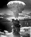
The Space Race was a 20th-century competition between two Cold War rivals, the United States and the Soviet Union, to achieve superior spaceflight capability. It had its origins in the ballistic missile-based nuclear arms race between the two nations following World War II and had its peak with the more particular Moon Race to land on the Moon between the US moonshot and Soviet moonshot programs. The technological advantage demonstrated by spaceflight achievement was seen as necessary for national security and became part of the symbolism and ideology of the time. The Space Race brought pioneering launches of artificial satellites, robotic space probes to the Moon, Venus, and Mars, and human spaceflight in low Earth orbit and ultimately to the Moon.
Public interest in space travel originated in the 1951 publication of a Soviet youth magazine and was promptly picked up by US magazines. The competition began on July 30, 1955, when the United States announced its intent to launch artificial satellites for the International Geophysical Year. Four days later, the Soviet Union responded by declaring they would also launch a satellite "in the near future". The launching of satellites was enabled by developments in ballistic missile capabilities since the end of World War II. The competition gained Western public attention with the "Sputnik crisis", when the USSR achieved the first successful satellite launch, Sputnik 1, on October 4, 1957. It gained momentum when the USSR sent the first human, Yuri Gagarin, into space with the orbital flight of Vostok 1 on April 12, 1961. These were followed by a string of other early firsts achieved by the Soviets over the next few years. (Full article...) -

The Hereford mappa mundi, a map of the world with Jerusalem at its centre
The Hereford Mappa Mundi (Latin: mappa mundi) is the largest medieval map still known to exist, depicting the known world. It is a religious rather than literal depiction, featuring heaven, hell and the path to salvation. The map is drawn in a form deriving from the T and O pattern, dating from c. 1300. It is displayed at Hereford Cathedral in Hereford, England. The map was created with the intent of its being appreciated as an intricate work of art rather than as a navigational tool. Sources for the information presented on the map include the Alexander tradition, medieval bestiaries and Monstrous races tradition, as well as the Bible.
Although the evidence is circumstantial, modern scholarship links the map with the promotion of the cult of Thomas de Cantilupe, and with a justification of the expulsion of Jewry from England. Potentially antisemitic images include a horned Moses and a depiction of Jews worshipping the Golden Calf in the form of a Saracen devil. The map also seems to reflect very patriarchical views of women as inherently sinful, including figures such as the wife of Lot being turned into a pillar of salt for gazing at the city of Sodom. Cantilupe was known for his dislike of Jews and was regarded as misogynistic even by the standards of his own time. (Full article...)
![Image 1 Protestors clash with Hong Kong police in the Wan Chai waterfront area during the WTO Ministerial Conference of 2005. Since its creation in 1995, the World Trade Organization (WTO) has worked to maintain and develop international trade. As one of the largest international economic organizations (alongside the International Monetary Fund (IMF) and the World Bank), it has strong influence and control over trading rules and agreements, and thus has the ability to affect a country's economy immensely. The WTO policies aim to balance tariffs and other forms of economic protection with a trade liberalization policy, and to "ensure that trade flows as smoothly, predictably and freely as possible". Indeed, the WTO claims that its actions "cut living costs and raise standards, stimulate economic growth and development, help countries develop, [and] give the weak a stronger voice." Statistically speaking, global trade has consistently grown between one and six percent per annum over the past decade, and US$38.8 billion were allocated to Aid for Trade in 2016. Yet several criticisms of the WTO have arisen over time from a range of fields, including economists such as Dani Rodrik and Ha Joon Chang, and anthropologists such as Marc Edelman, who have argued that the institution "only serves the interests of multinational corporations, undermines local development, penalizes poor countries, [and] is increasing inequality", and have argued that some agreements about agriculture and pharmaceutical goods have led to restricted access to food and healthcare, thus causing large numbers of deaths. Several factors are alleged to contribute to these conditions, including but not limited to: the most favoured nation rule (MFN), national treatment policies, and failure to regard the infant industry argument. Critics argue that the policies that support these principles fail to protect developing nations, and in some cases take advantage of them. For example, UNCTAD estimates that market distortions cost developing countries $700 billion annually in lost export revenue. (Full article...)](https://cdn.sessionspy.com:443/index.php?https://en.wikipedia.org/wiki/File:Blank.png)


General images -
-
-
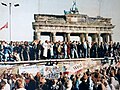 Fall of the Berlin Wall, 1989
 -
-
-
-
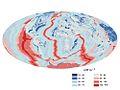
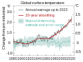 Change in average surface air temperature and drivers for that change. Human activity has caused increased temperatures, with natural forces adding some variability. (from Earth)
 -
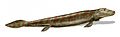 Tiktaalik, a fish with limb-like fins and a predecessor of tetrapods. Reconstruction from fossils about 375 million years old. (from History of Earth)
 -
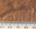 A 580 million year old fossil of Spriggina floundensi, an animal from the Ediacaran period. Such life forms could have been ancestors to the many new forms that originated in the Cambrian Explosion. (from History of Earth)
 -
-
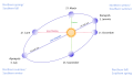
 Earth's axial tilt causing different angles of seasonal illumination at different orbital positions around the Sun (from Earth)
 -
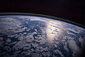
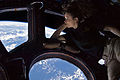 Tracy Caldwell Dyson, a NASA astronaut, observing Earth from the Cupola module at the International Space Station on 11 September 2010 (from Earth)
 -
 A 2012 artistic impression of the early Solar System's protoplanetary disk from which Earth and other Solar System bodies were formed (from Earth)
 -
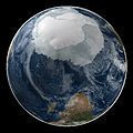 A composite image of Earth, with its different types of surface discernible: Earth's surface dominating Ocean (blue), Africa with lush (green) to dry (brown) land and Earth's polar ice in the form of Antarctic sea ice (grey) covering the Antarctic or Southern Ocean and the Antarctic ice sheet (white) covering Antarctica. (from Earth)
 -
 Graph showing range of estimated partial pressure of atmospheric oxygen through geologic time (from History of Earth)
 -
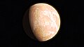 Pale orange dot, an artist's impression of Early Earth, featuring its tinted orange methane-rich early atmosphere (from Earth)
 -
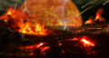 Artist's impression of a Hadean landscape with the relatively newly formed Moon still looming closely over Earth and both bodies sustaining strong volcanism. (from History of Earth)
 -
The pale orange dot, an artist's impression of the early Earth which might have appeared orange through its hazy methane rich prebiotic second atmosphere. Earth's atmosphere at this stage was somewhat comparable to today's atmosphere of Titan. (from History of Earth)
-
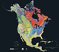 Geologic map of North America, color-coded by age. From most recent to oldest, age is indicated by yellow, green, blue, and red. The reds and pinks indicate rock from the Archean.
 -
-
 Satellite time lapse imagery of Earth's rotation showing axis tilt (from Earth)
 -
 Earth's night-side upper atmosphere appearing from the bottom as bands of afterglow illuminating the troposphere in orange with silhouettes of clouds, and the stratosphere in white and blue. Next the mesosphere (pink area) extends to the orange and faintly green line of the lowest airglow, at about one hundred kilometers at the edge of space and the lower edge of the thermosphere (invisible). Continuing with green and red bands of aurorae stretching over several hundred kilometers. (from Earth)
 -
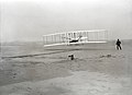 First airplane, the Wright Flyer, flew on 17 December 1903.
 -
 Chloroplasts in the cells of a moss (from History of Earth)
 -
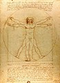 Vitruvian Man by Leonardo da Vinci epitomizes the advances in art and science seen during the Renaissance. (from History of Earth)
 -
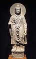 Standing Buddha from Gandhara, 2nd century CE
 -
 An artist's impression of ice age Earth at glacial maximum. (from History of Earth)
 -
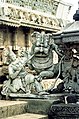 Chennakesava Temple, Belur, India
 -
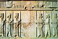 Persepolis, Achaemenid Empire, 6th century BCE
 -
 Artist's conception of Devonian flora (from History of Earth)
 -
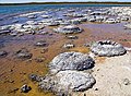 Lithified stromatolites on the shores of Lake Thetis, Western Australia. Archean stromatolites are the first direct fossil traces of life on Earth. (from History of Earth)
 -
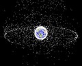 A computer-generated image mapping the prevalence of artificial satellites and space debris around Earth in geosynchronous and low Earth orbit (from Earth)
 -
-
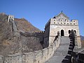 Ming dynasty section, Great Wall of China
 -
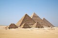 Great Pyramids of Giza, Egypt
 -
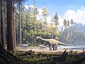 Dinosaurs were the dominant terrestrial vertebrates throughout most of the Mesozoic (from History of Earth)
 -
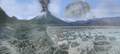 An artist's impression of the Archean, the eon after Earth's formation, featuring round stromatolites, which are early oxygen-producing forms of life from billions of years ago. After the Late Heavy Bombardment, Earth's crust had cooled, its water-rich barren surface is marked by continents and volcanoes, with the Moon still orbiting Earth half as far as it is today, appearing 2.8 times larger and producing strong tides. (from Earth)
 -
-
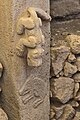 A pillar at Göbekli Tepe
 -
 A view of Earth with different layers of its atmosphere visible: the troposphere with its clouds casting shadows, a band of stratospheric blue sky at the horizon, and a line of green airglow of the lower thermosphere around an altitude of 100 km, at the edge of space (from Earth)
 -
 A reconstruction of human history based on fossil data. (from History of Earth)
 -
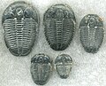 Trilobites first appeared during the Cambrian period and were among the most widespread and diverse groups of Paleozoic organisms. (from History of Earth)
 -
-
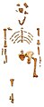 "Lucy", the first Australopithecus afarensis skeleton found. Lucy was only 1.06 m (3 ft 6 in) tall.
 -
 Pangaea was a supercontinent that existed from about 300 to 180 Ma. The outlines of the modern continents and other landmasses are indicated on this map. (from History of Earth)
 -
 An animation of the changing density of productive vegetation on land (low in brown; heavy in dark green) and phytoplankton at the ocean surface (low in purple; high in yellow) (from Earth)
 -
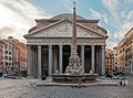 The Pantheon, originally a Roman temple, now a Catholic church
 -
 Earth's history with time-spans of the eons to scale (from History of Earth)
 -
-
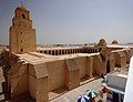 Great Mosque of Kairouan, Tunisia, founded 670 CE
 -
-
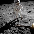
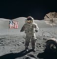 Last Moon landing: Apollo 17 (1972)
 -
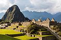 Machu Picchu, Inca Empire, Peru
 -
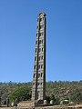 Obelisk of Axum, Ethiopia
 -
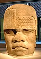 Olmec colossal head, now at the Museo de Antropología de Xalapa
 -
-
-
 Artist's conception of Hadean Eon Earth, when it was much hotter and inhospitable to all forms of life. (from History of Earth)
 -
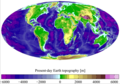
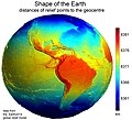 Earth's western hemisphere showing topography relative to Earth's center instead of to mean sea level, as in common topographic maps (from Earth)
 -
-
 A view of Earth with its global ocean and cloud cover, which dominate Earth's surface and hydrosphere; at Earth's polar regions, its hydrosphere forms larger areas of ice cover. (from Earth)
 -
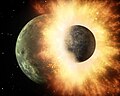 Artist's impression of the enormous collision that probably formed the Moon (from History of Earth)
 -
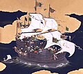 Japanese depiction of a Portuguese carrack. European maritime innovations led to proto-globalization.
 -
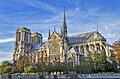 Notre-Dame de Paris, France
 -
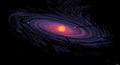 An artist's rendering of a protoplanetary disk (from History of Earth)
 -
-
 Battle during 1281 Mongol invasion of Japan
 -

-
-
 View of Earth from the Moon by the Lunar Reconnaissance Orbiter (from Earth)
 -
 A map of heat flow from Earth's interior to the surface of Earth's crust, mostly along the oceanic ridges (from Earth)
 -
 Cross-section through a liposome (from History of Earth)
 -
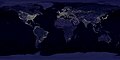 A composite image of artificial light emissions at night on a map of Earth (from Earth)
 -
-
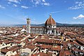 Florence, birthplace of the Italian Renaissance
 -
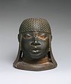 A Benin Bronze head from Nigeria
 -
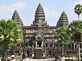 Angkor Wat temple complex, Cambodia, early 12th century
 -
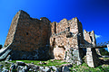 Ajloun Castle, Jordan
 -
 Empires of the world in 1898
 -
 Artist's rendition of an oxinated fully-frozen Snowball Earth with no remaining liquid surface water. (from History of Earth)
 -
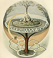 Yggdrasil, an attempt to reconstruct the Norse world tree which connects the heavens, the world, and the underworld. (from World)
 -
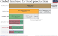 Earth's land use for human agriculture in 2019 (from Earth)
 -
-
-
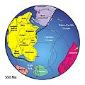 A reconstruction of Pannotia (550 Ma). (from History of Earth)
 -
 The replicator in virtually all known life is deoxyribonucleic acid. DNA is far more complex than the original replicator and its replication systems are highly elaborate. (from History of Earth)
 -
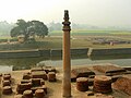
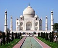 Taj Mahal, Mughal Empire, India
 -
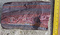 A banded iron formation from the 3.15 Ga Moodies Group, Barberton Greenstone Belt, South Africa. Red layers represent the times when oxygen was available; gray layers were formed in anoxic circumstances. (from History of Earth)
 -
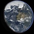
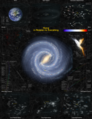
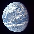
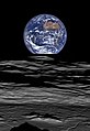
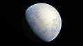
 Image of the physical world, captured by the Hubble Space Telescope (from World)
 -
Artist's impression of Earth during the later Archean, the largely cooled planetary crust and water-rich barren surface, marked by volcanoes and continents, features already round microbialites. The Moon, still orbiting Earth much closer than today and still dominating Earth's sky, produced strong tides. (from History of Earth)
-
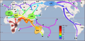 Map of peopling of the world (Southern Dispersal paradigm), in thousands of years ago.
 -
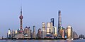 Shanghai. China urbanized rapidly in the 21st century.
 -
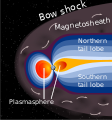 A schematic view of Earth's magnetosphere with solar wind flowing from left to right (from Earth)


.svg)


.jpg)

.jpg)
.jpeg)


.jpg)


Megacities of the world -

Lahore (/ləˈhɔːr/ lə-HOR; Punjabi: لہور [lɔː˩˥ɾ]; Urdu: لاہور [laːˈɦɔːɾ] ⓘ) is the capital and largest city of the Pakistani province of Punjab. It is the second largest city in Pakistan, after Karachi, and the 26th largest in the world, with a population of over 13 million. It is located in the north-eastern region of Punjab, along the River Ravi. Lahore is one of Pakistan's major industrial and economic hubs. It has been the historic capital and cultural centre of the wider Punjab region, and is one of Pakistan's most socially liberal, progressive, and cosmopolitan cities.
Lahore's origin dates back to antiquity. The city has been inhabited for around two millennia, although it rose to prominence in the late 10th century. Lahore was the capital of several empires during the medieval era, including the Hindu Shahis, Ghaznavids and Delhi Sultanate. It reached the height of its splendor under the Mughal Empire between the late 16th and early 18th centuries and also served as its capital city for many years. During this period, it was one of the largest cities in the world. The city was captured by the forces of the Afsharid ruler Nader Shah in 1739. Although the Mughal authority was re-established, it fell into a period of decay while being contested among the Afghans and the Sikhs between 1748 and 1798. Lahore eventually became the capital of the Sikh Empire in the early 19th century, regaining some of its lost grandeur. Lahore was annexed to the British Raj in 1849 and became the capital of British Punjab. Lahore was central to the independence movements of both India and Pakistan, with the city being the site of both the Declaration of Indian Independence and the resolution calling for the establishment of Pakistan. It experienced some of the worst rioting during the Partition period preceding Pakistan's independence. Following the success of the Pakistan Movement and the subsequent partition of British India in 1947, Lahore was declared the capital of Pakistan's Punjab province. (Full article...)Did you know -

- ... that a photograph of Frances "the Shape" Vorne wearing a swimsuit made from remnants of a captured Nazi parachute was one of the most sought-after pin-ups of World War II?
- ... that Oakwood Cemetery contains the graves of Confederate soldiers and officers, English, Canadian, and French World War II pilots, and Hank Williams?
- ... that Gateshead Millennium Bridge is the world's first tilt bridge?
- ... that the construction of the Masurian Canal was paused for the World Wars and hyperinflation in the Weimar Republic before being abandoned?
- ... that the fixed anvil temperature hypothesis proposes that anvil clouds do not remove excess radiation as the Earth's surface temperature increases?
- ... that more than 22,000 earthquakes occurred in the eight days before the 2021 Cumbre Vieja volcanic eruption?
- ... that the music hall song "Let's All Go Down the Strand", with its line "stay away from Germany, what's the good of going down the Rhine?" was popular with British soldiers during the First World War?
- ... that Mack Trucks adopted the Bulldog as its corporate logo after World War I British soldiers nicknamed the Mack AC the "Bulldog", a reference to the model's tenacity and stub nose?
Countries of the world -

São Tomé and Príncipe (/ˌsaʊ təˈmeɪ ... ˈprɪnsɪpə, -peɪ/ ⓘ SOW tə-MAY ... PRIN-sih-pə, -pay; Portuguese: São Tomé e Príncipe (Portuguese pronunciation: [sɐ̃w tuˈmɛ i ˈpɾĩsɨpɨ]); English: "Saint Thomas and Prince"), officially the Democratic Republic of São Tomé and Príncipe (Portuguese: República Democrática de São Tomé e Príncipe), is an island country in the Gulf of Guinea, the western equatorial coast of Central Africa.
It consists of two archipelagos around the two main islands of São Tomé and Príncipe, about 150 km (93.21 mi) apart and about 250 and 225 km (155 and 140 mi) off the northwestern coast of Gabon. With a population of 201,800 (2018 official estimate), São Tomé and Príncipe is the second-smallest and second-least populous African sovereign state after Seychelles. It is also the smallest Romance-speaking country outside of Europe in terms of population and area. (Full article...)Related portals
Protected areas of the world -
-
The Australian Capital Territory as of 2014 contains 46 separate protected areas with a total land area of 1,302 km2 (503 sq mi) or 55.5% of the territory's area, and which managed by Territory and Municipal Services of the ACT government: (Full article...)
-

Mombacho Volcano Natural Reserve
The protected areas of Nicaragua are areas that have natural beauty or significance and are protected by Nicaragua. Nicaragua has 78 protected areas that cover 22,422 km2, about 17.3% of the nations landmass. The National System of Protected Areas (SINAP) is administered by the Ministry of the Environment and Natural Resources (MARENA). (Full article...) -
This list of protected areas of Myanmar includes national parks, wildlife sanctuaries and botanical gardens that were established since 1927. (Full article...)
-
Kentucky's system of 44 state parks has been referred to as "the nation's finest" and experiences more repeat business annually than those of any other U.S. state. The state's diverse geography provides a variety of environments to experience. From mountain lakes to expansive caves to forests teeming with wildlife, park-goers have their choice of attractions, and they are all within a day's drive of each other.
Unless otherwise specified, data in the following lists are taken from Kentucky State Parks by Bill Bailey. (Full article...) -

There are numerous parks throughout the sovereign island country of Singapore. This is a list of parks in Singapore that are currently existing and have articles on Wikipedia. Most parks in Singapore are managed by the National Parks Board, although smaller neighbourhood parks are managed by the Housing Development Board. Most of these parks are connected via the Park Connector Network (PCN). (Full article...) -

Part of the Brecon Beacons National Park, looking from the highest point of Pen y Fan (886 m/2907 feet) to Cribyn (795 m/2608 feet).
Protected areas of the United Kingdom are areas in the United Kingdom which need and /or receive protection because of their environmental, historical or cultural value to the nation. Methods and aims of protection vary depending on the nature and importance of the resource. Protection operates at local, regional, national and international levels, and may be backed by legislation and international treaty, or less formally by planning policy.
Within the United Kingdom, different approaches are taken to some forms of protection within the constituent countries of England, Scotland, Wales and Northern Ireland, while other forms of protection are more consistent across the UK. Protected areas can be divided according to the type of resource which each seeks to protect. Primarily, these are: scenic or landscape value; biodiversity value (species and habitats); geodiversity value (relating to geology and geomorphology); and cultural or historic value. Several types of protected areas are focused on more than one of these areas. (Full article...) -
The National Parks of Argentina make up a network of 35 national parks in Argentina. The parks cover a very varied set of terrains and biotopes, from Baritú National Park on the northern border with Bolivia to Tierra del Fuego National Park in the far south of the continent. The Administración de Parques Nacionales (National Parks Administration) is the agency that preserves and manages these national parks along with Natural monuments and National Reserves within the country.
The headquarters of the National Parks Service are in downtown Buenos Aires, on Santa Fe Avenue. A library and information centre are open to the public. The administration also covers the national monuments, such as the Jaramillo Petrified Forest, and natural and educational reserves. (Full article...) -

Rano Kau, Parque National Rapa Nui, Easter Island
The protected areas of Chile are areas that have natural beauty or significant historical value protected by the government of Chile. These protected areas cover over 140,000 km2 (54,054 sq mi), which is 19% of the territory of Chile. The National System of Protected Wild Areas (SNASPE by its Spanish acronym) is regulated by law #18,362 passed in 1984, and administered by the National Forest Corporation (CONAF).
There are three types of territories: (Full article...) -

Map of protected areas of the Czech Republic: national parks (grey) and protected landscape areas (green)
There are several types of protected areas of the Czech Republic. The main form of landscape protection is delimitation of special protected areas. All the types of protected areas are determined by law. (Full article...) -
This is a list of protected areas of Yukon. The Yukon, formerly called Yukon Territory and sometimes referred to as just Yukon is the smallest and westernmost of Canada's three territories. It also is the least populated province or territory in Canada, with a population of 35,874 people as of the 2016 Census. (Full article...) -
This list of protected areas of Quebec includes federally, provincially and municipally administered parks and wildlife reserves in Quebec, the largest province in Canada. (Full article...) -
Protected areas of Libya include any geographical area protected for a specific use.
Most protected areas are intended for the conservation of flora and fauna. Libya's national parks and nature reserves are maintained by the "Technical Committee of Wildlife and National Parks" which was created in 1990, as part of the General Secretariat of Agricultural Reclamation and Land Reform. (Full article...) -
-
-
Protected areas of Indonesia comprise both terrestrial and marine environments in any of the six IUCN Protected Area categories. There are over 500 protected areas in Indonesia, of which 54 National Parks cover 16.4 million ha, and another 527 nature and game reserves cover a further 28.3 million ha. The total protected land area represents over 15% of Indonesia's landmass. Marine Protected Areas comprise over 15.7 million ha representing ca. 5% of territorial waters. (Full article...)


Selected world maps
-
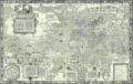
 1516 map of the world by Martin Waldseemüller
 -
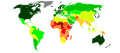 United Nations Human Development Index map by country (2016)
 -
 Only a few of the largest large igneous provinces appear (coloured dark purple) on this geological map, which depicts crustal geologic provinces as seen in seismic refraction data
 -
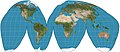
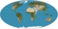 Mollweide projection of the world
 -
 The world map by Gerardus Mercator (1569), the first map in the well-known Mercator projection
 -
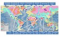
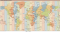 Time zones of the world
 -
 Index map from the International Map of the World (1:1,000,000 scale)
 -
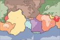
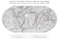 A plate tectonics map with volcano locations indicated with red circles
 -
 The Goode homolosine projection is a pseudocylindrical, equal-area, composite map projection used for world maps.


World records
- List of Olympic records in athletics
- List of world records in athletics
- List of junior world records in athletics
- List of world records in masters athletics
- List of world youth bests in athletics
- List of IPC world records in athletics
- List of world records in canoeing
- List of world records in chess
- List of cycling records
- List of world records in track cycling
- List of world records in finswimming
- List of world records in juggling
- List of world records in rowing
- List of world records in speed skating
- List of world records in swimming
- List of IPC world records in swimming
- List of world records in Olympic weightlifting
Topics

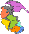
Continents of Earth | ||||||||
|---|---|---|---|---|---|---|---|---|
| ||||||||
| ||||||||
| ||||||||


| Cenozoic Era (present–66.0 Ma) |
| ||||||||||||
|---|---|---|---|---|---|---|---|---|---|---|---|---|---|
| Mesozoic Era (66.0–252 Ma) |
| ||||||||||||
| Paleozoic Era (252–539 Ma) |
| ||||||||||||
| Proterozoic Eon (539 Ma–2.5 Ga) |
| ||||||||||||
| Archean Eon (2.5–4 Ga) | |||||||||||||
| Hadean Eon (4–4.6 Ga) | |||||||||||||
ka = kiloannum (thousands years ago); Ma = megaannum (millions years ago); Ga = gigaannum (billions years ago). See also: Geologic time scale • | |||||||||||||
| Locations | ||
|---|---|---|
| Related | ||

| |||||||||||||||||||
| |||||||||||||||||||
| |||||||||||||||||||

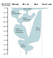
Economic classification of countries | |||||
|---|---|---|---|---|---|
| Three-World Model | |||||
| Gross domestic product (GDP) |
| ||||
| Gross national income (GNI) | |||||
| Wages | |||||
| Wealth | |||||
| Other national accounts | |||||
| Human development | |||||
| Digital divide | |||||
| Net international investment position (NIIP) | |||||
| Technological |
| ||||
|---|---|---|---|---|---|
| Sociological | |||||
| Ecological |
| ||||
| Biological |
| ||||
| Astronomical | |||||
| Eschatological |
| ||||
| Others |
| ||||
| Fictional | |||||
| Organizations | |||||
Categories

Wikimedia
The following Wikimedia Foundation sister projects provide more on this subject:
-
 Commons
Free media repository -
 Wikibooks
Free textbooks and manuals -
 Wikidata
Free knowledge base -
 Wikinews
Free-content news -
 Wikiquote
Collection of quotations -
 Wikisource
Free-content library -
 Wikispecies
Directory of species -
 Wikiversity
Free learning tools -
 Wikivoyage
Free travel guide -
 Wiktionary
Dictionary and thesaurus


